Контентге кёч

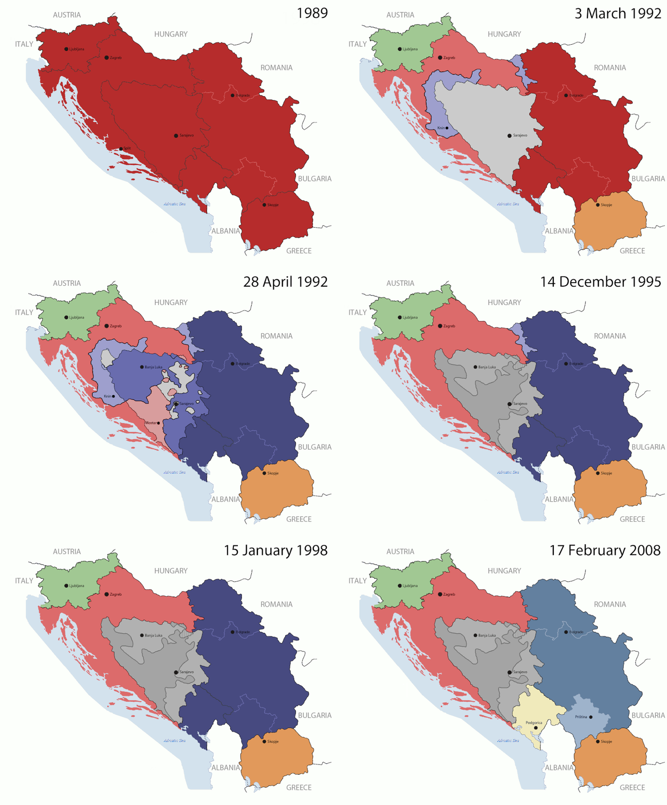
Файл:Breakup of Yugoslavia.gif

Бетни ичиндегиси башха тилледе дагъан кёрмейди.
Википедия — эркин энциклопедияны бети.

Чыкъгъан файл(1545 × 1242 пиксель, файлны ёлчеми: 187 КБ, MIME типи: image/gif, тогъайланнганды, 14 фрейм, 44 с)

This image could be re-created using vector graphics as an SVG file. This has several advantages; see Commons:Media for cleanup for more information. If an SVG form of this image is available, please upload it and afterwards replace this template with {{vector version available|new image name}}. It is recommended to name the SVG file "Breakup of Yugoslavia.svg" - then the template Vector version available (or Vva) does not need the new image name parameter.

Къысха ачыкълау

Key:

Yugoslavia (1943–1992) SFR Yugoslavia
Croatia (1991–present) Croatia
Herzeg-Bosnia (1992–1994)
UNTAES (1996–1998)
Federal Republic of Yugoslavia / Serbia and Montenegro (1992–2006) Serbia and Montenegro
Republika Srpska (1992–present) Republika Srpska
Serbian Krajina (1991–1995/96)
Republic of Bosnia and Herzegovina (1992–1995)
Bosnia and Herzegovina (1998–present) Bosnia and Herzegovina
Western Bosnia (1993–1995)
Serbia (2006–present) Serbia
Kosovo (under UNMIK control 1999–present; declaration of independence 2008) Kosovo
Montenegro (2006–present) Montenegro
Macedonia (1991–present) Macedonia
Slovenia (1991–present) Slovenia


Ачыкълау

This is an animated GIF that shows the stages of the breakup of the SFR Yugoslavia in the 90's and 2000's. The map based off Morwen's map of the divisions of the SFRY, Which is licensed by the GFDL. The source for the dates of independence is the CIA World Factbook. These maps do not now show the Inter-Entity Boundary Line (IEBL) and/or the entities that are separated by it. The IEBL has been drawn based on this CIA map; the Brčko District has been drawn based on Image:BH municipality location.gif, by user:Ante Perkovic. I might add them in the future.

Since the original map was GFDL, this image is as well.

A map depicting Kosovo's final status is ready once it takes effect.


Changelog for versions 2/3:

Here are some changes in this new build of the map:

  • The Kosovo boundary has been given a shade of red instead of the previous UN blue since they are a province of Serbia under UNIMIK control.
  • Montenegro's color has been changed to a golden shade close to what's on the flag.
  • The IEBL and the Brčko District has been redrawn because I deleted the original map; the color for the Republika Srpska is lighter.
  • The dates are at the top left hand corner of the map instead of the bottom.
  • I have taken a new approach as to the boundaries. Each part of Yugoslavia now shows the boundary on the maps starting the year they broke away. I feel this change helps readers understand the breakup better.
  • The SFRY and the FRY are in different shades since the FRY was never accepted as the successor to the former by the UN.
  • The colors for the entities of BiH have been removed as to not confuse people into thinking that they are independent states. What remains is the IEBL with both entities in green.
  • The Kosovo boundary is finally in hash marks!
  • The Brčko District has been removed. The sale is too small to show accurately.

Changelog for version 4:

  • The map is larger!
  • The image has been rebuilt to include the eastern part of FYR Macedonia.
  • The image has been updated to take in Kosovo's new status.
  • The IEBL is now a darker line.
  • Montenegro, Kosovo, and FRY/SCG/Serbia have new colors!

Changelog for version 5:

  • Rebuilt
  • Larger map: size of base image
  • Accurate Inter-Entity Boundary Line
Дата 24 July 2006 (orginal upload date)
Къайнакъ Made by Hoshie; see above for more details on sources.
Автор Hoshie
Другие версии

Лицензияланыу

GNU head Бу документни, Эркин программа баджарыу фонд публикация этген GNU Free Documentation License лицензияны 1.2 версиясыны неда андан кечирек версиясыны шартларына кёре, тюрленмеучю бёлюмлесиз, ал эм арт тышха салыныучю текстлесиз копия этерге, джаяргъа эмда/неда тюрлендирирге эркинлик бериледи. Лицензияны копиясы, GNU Free Documentation License деб баш салыннган бёлюмге къошулгъанды.
w:krc:Creative Commons
авторлукъну чертиу джайылгъаны да аллай шартла блады
Бу файл, Creative Commons Attribution-Share Alike 3.0 Unported лицензияны шартларында бериледи
Сизни эркин мадарыгъыз барды:
  • башхалагъа берирге – копия этерге, джаяргъа эм берирге бу чыгъарманы
  • башха чыгъарма этерге – тюрлендирирге бу чыгъарманы
Бу келишимледен чыкъмагъанлай:
  • авторлукъну чертиу – Бу чыгъарманы авторуна (неда джорукъгъа кёре иесине) джибериу салыргъа керексиз, кеси да автор неда лицензиат бегитген халда болургъа керекди (алай а ариу не болса да автор сизни неда бу чыгъарманы хайырландырыуугъузну джакълагъанча акъылгъа бурмазгъа керекди).
  • джайылгъаны да аллай шартла блады – Бу чыгъарманы тюрлендирген эте эсигиз неда аны тамалында башха чыгъарма къурай эсегиз, чыкъгъан чыгъарманы къуру туура аллай лицензияны неда бир-бирин тутхан лицензияны шартларына кёре джаяргъа боллукъду.
Этот признак лицензирования был добавлен к этому файлу как часть обновления лицензии GFDL.

Краткие подписи

Добавьте однострочное описание того, что собой представляет этот файл

Элементы, изображённые на этом файле

изображённый объект русский

создатель русский

У этого свойства есть некоторое значение без элемента в

MIME-тип русский

image/gif

05ca2aefea8406b809968643552d5095c847a42f

метод определения русский: SHA-1 русский

191 625 байт

44 секунд

высота/рост русский

1242 пиксель

ширина русский

1545 пиксель

Файлны тарихи

Датагъа/заманнга басыгъыз, ол сагъатда файл къаллай болгъанын кёрюр ючюн.

(эм джангыла | эм эскиле) Къара: (10 джангыракъ | ) (10 | 20 | 50 | 100 | 250 | 500)
Дата/заманМиниатюраЁлчемиХайырланыучуКомментарий
бусагъатдагъы07:40, 17 июль 201607:40, 17 июль 2016 кюнден версияны миниатюрасы1545 × 1242 (187 КБ)מפתח-רשימהReverted to version as of 17:22, 21 August 2015 (UTC)
17:22, 21 август 201517:22, 21 август 2015 кюнден версияны миниатюрасы1463 × 1158 (1,81 МБ)BraganzaReverted to version as of 03:57, 19 January 2010
17:22, 21 август 201517:22, 21 август 2015 кюнден версияны миниатюрасы1545 × 1242 (187 КБ)BraganzaReverted to version as of 01:02, 19 December 2011
17:15, 21 август 201517:15, 21 август 2015 кюнден версияны миниатюрасы120 × 95 (3 КБ)Braganza03:57, 19. Jan. 2010
01:02, 19 декабрь 201101:02, 19 декабрь 2011 кюнден версияны миниатюрасы1545 × 1242 (187 КБ)DIREKTORAdded details
18:09, 27 июль 201118:09, 27 июль 2011 кюнден версияны миниатюрасы1545 × 1242 (170 КБ)DIREKTORSmall fixes
17:28, 27 июль 201117:28, 27 июль 2011 кюнден версияны миниатюрасы1545 × 1242 (171 КБ)DIREKTORAdded UNMIK
16:38, 27 июль 201116:38, 27 июль 2011 кюнден версияны миниатюрасы1545 × 1242 (165 КБ)DIREKTORDates for the last two frames.
12:10, 27 июль 201112:10, 27 июль 2011 кюнден версияны миниатюрасы1545 × 1242 (149 КБ)DIREKTORLighter shade for country names
16:59, 26 июль 201116:59, 26 июль 2011 кюнден версияны миниатюрасы1545 × 1242 (170 КБ)DIREKTORHigher res plus details
(эм джангыла | эм эскиле) Къара: (10 джангыракъ | ) (10 | 20 | 50 | 100 | 250 | 500)

Бу файлны, джангыз бет хайырландырады:

Файлны глобал хайырланыуу

Бу файл бу викиледе хайырландырылады:

Бу файлны глобал хайырландырылыуун кёрюу.

Метабилгиле